TERROIR
The nature of rock and the stratification of the soil directly affect the growth pattern of plants, by influencing their take-up of water and minerals. The grapevine is one of the plants most sensitive to such pedoclimatic changes; even though it demonstrates a certain degree of hardiness that allows it to adapt to a considerable range of soils, it does respond physiologically in different ways to even limited variations.
This individual response ensures that each vineyard, and thus the wine that it yields, represents a natural unit inseparable from the piece of earth that generated it, and it thus can be rightly considered a unique and irreproducible natural heritage in itself.
These are the reasons that justified our decision to vinify separately our various blocks of grapes, preserving their expressive purity of their source of origin.
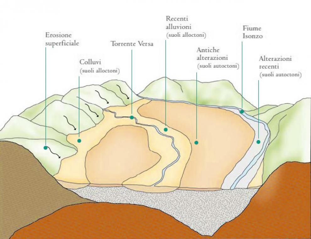
To give a completely accurate idea of our area, we must point out that not all of its soils reflect exactly the characteristics and formation process described in the preceding section.
One must in fact distinguish between autochthonous soils, those formed in loco, and allochthonous soils, those formed elsewhere and transported by water and subsequently deposited as sediment. The first are the soils described previously, and on which our vineyards are planted. The second category, on the other hand, was formed by recent alluviation provided by streams that carried clays from morainic hills. Those soils have no grainy-pebbly texture but are primarily composed of dense clays, very deep, of uniform character, and devoid of stratification. The high fertility and abundant water-holding capacity of such soils allows higher-yielding vineyards, suitable for a different kind of winemaking.
The same characteristics are present in colluvial deposits, formed by clays washed down from morainic slopes; these washes accumulate at the foot of hills, covering a narrow strip of Eocene benchlands.
The local area is thus characterised by two quite distinct soil typologies, and those soils deriving from alteration processes occurring in loco represent, for us, the most valuable vineyard sites.
ORIGIN OF TERRITORY
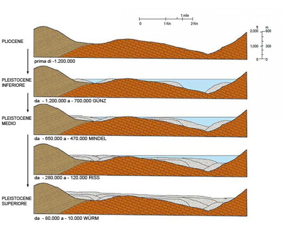
The origin of the area dates back to the Pleistocene epoch, a period that experienced four successive periods of glaciation.
Each glaciation period witnessed climatic oscillations that caused alternating phases of significant glacier extension and retreat. Each period of glaciation, marked by cold climate, was separated from a successive period by a relatively warm interval (interglacial period) that brought about a constant retreat of the glaciers. It is believed that the glaciation periods were caused by decreased solar strength, due either to the formation of sunspots or to dust clouds between the sun and the earth that interfered with solar radiation. The first cold stage, known as Günz, began 1,200,000 years ago and lasted for 500,000 years; it was followed by a 50,000-year warm, humid period that in this local area encouraged the spread of equatorial flora and fauna. The second glaciation phase, Mindel, lasting from 650,00 to 300,000 years ago, was the coldest of the four. A warm period of 50,000 years preceded the third glaciation, Riss, lasting from 250,000 to 120,00 years ago, which was followed by another warm interval of 40,000 years. The Würm, the fourth and last glaciation, took place between 80,000 and 10,000 years ago. Every glaciation period, before the full onset of a warmer interval, phases into a cataglacial stage of glacier dissolution, when the released waters carry down into the valleys enormous quantities of material eroded from the Alps, forming extensive alluvial fans.
The successive addition of layers of alluvial materials from different periods gradually filled the valley of the river Isonzo, creating extensive benches sloping southwest, with an average incline of 0.5%. With the end of the Würm and the beginning of the Holocene, the flow of water dropped substantially, bringing the water of the river into narrower banks and thus exposing the alluvial benches upon which today’s soils began to develop.
PEDOGENESIS
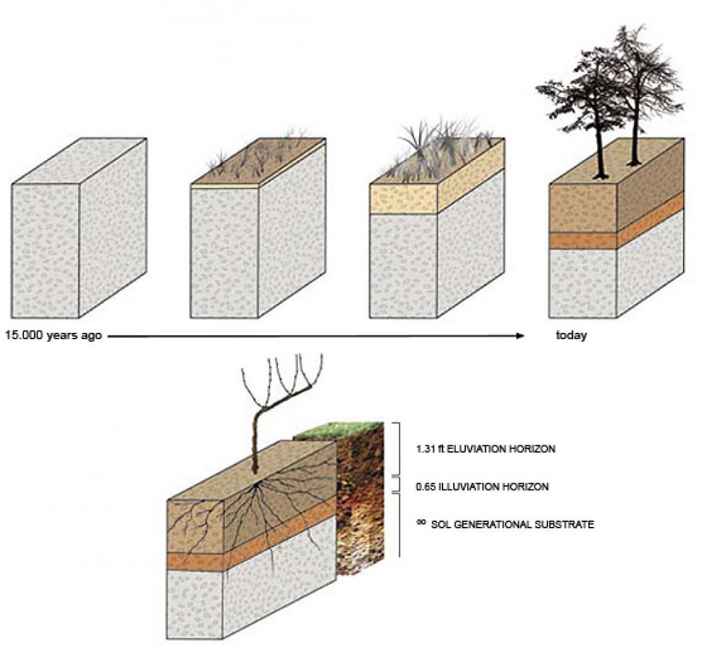
Pedogenesis, or soil formation, is the process of geological alteration of source rock that gives rise to soils. Every rocky substrate tends, over time, to achieve a relatively stable equilibrium with the external environment, and in particular with the atmosphere, through very gradual, but profound, chemical-physical modifications.
Soil formation occurs through various stages that begin with the physical-mechanical breakdown effected by the weather, by means of significant thermal fluctuations that fissure the rock and thus open it up to rain water. Rocks, composed of layers of various minerals, tend to break apart starting at the surface, which has greater exposure to the forces of freezing and thawing. To this must be added chemical decomposition of the rock through the solvent properties of water: water’s carbonic acid content enables it to solubilise the calcium carbonate in minerals. When the rocks are thus de-calcified, they are weakened and begin to release the mineral elements that are indispensable to the first colonizers of the soil, the lower-order plants. The first organisms to establish themselves are mosses and lichens; by producing certain enzymes they are able to biologically degrade the minerals in order to extract the elements they need to build their own biomass. The natural biological cycle of such plants leads to the formation of a thin organic stratum that in turn allows the soil to host plants with more demanding nutritional requirements. Thus, through the combined action of all these described phenomena, there occurs a gradual but profound alteration of the original minerals and the formation of an organic component that represents the premise and the basis for each soil’s degree of fertility.
Over the course of millennia, and in long cycles of the subtlest changes, various elements in the soil shift downwards from the surface, and the soil thus gradually diversifies into different strata and horizons.
Simplifying a bit, we can distinguish three separate horizons in a soil profile:
The first, and closest to the surface, is called the eluvial horizon; it is the richest in organic humus substances and displays greater biological activity. Darker in colour, it undergoes the leaching effect of water, with calcium carbonates being thus deposited into lower strata. Any clays that occur, formed from the breakdown of silicates, are mixed with a gravely schist that can amount to 50% of soil volume.
The second horizon, called the illuvial zone, is where the carbonates accumulate, as well as certain cations such as iron, alluminium, and other minor elements that made up the source rock.
The deepest and last layer, called the pedogenetic substratum, is composed of un-decomposed rock, the same material present on the surface predating the degradation process.
The current profile of a soil does not, of course, represent the endpoint of that soil’s evolution, inasmuch as the process of change will continue, affecting ever deeper strata, forming soils with ever higher clay content; of darker colour, given the accumulation of organic materials; and with ever finer texture containing only hard, more permanent mineral complexes, such as granites and quartzes.
This slow evolution of soil, called ferritization, will go on for thousands and thousands of years until new orogenetic movements will modify the earth’s crust or until new glaciers will cover the area with new layers of rocky materials coming down from the Alps.
CLIMATE
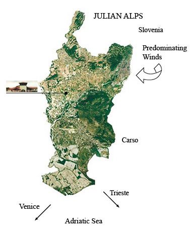
This region is a unique area where different winds, from the Adriatic and from the northern continent, both humid and dry, cool and warm, converge and direct themselves in different directions, thus creating a climate marked by constant change.
The colder continental east winds (the Bora) and the warmer, more humid scirocco winds from the Mediterranean prevail at different times of the year. During the vine’s main growth period, we experience, in an average year, a humid, rainy spring, a moderately warm, dry summer, and cool autumns that can be either dry or rainy. It is autumn, with its alternating weather, that determines whether any given year will be characterized as continental-European or northern-Mediterranean.
The area’s outstanding suitability for viticulture is largely a result of the cool, dry Bora that sweeps east from the wide, open valleys in the mountains of Slovenia and onto the Isonzo plateau. These winds, by ensuring a wide daily temperature range and, indirectly, longer solar exposure, favour a slow ripening of the grapes.
PRODUCTION AREA
Our sixty hectares of planted vineyard are located in the Mariano del Friuli township, located within the DOC zone of Friuli Isonzo, in the easternmost area of northern Italy, close to the Slovenian border. The Adriatic is barely 20 km to the south, and the first slopes of the Alps about 30 km to the north.
Within the Isonzo area, we are situated on a broad terrace on the north bank of the river Isonzo.
The satellite photo reveals the faint reddish coloration of this area, due to high concentrations of ferrous oxides.
